|
|
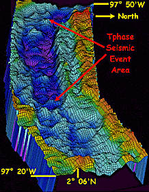
A 3-D image of the multibeam sonar data collected using the system on board RV Melville last week. Uta Peckman processed the data to produce this image. Note the bumpy topography in the axis of the rift valley (the dark blue area in the center of the image). We suspect that these bumps are small volcanoes where young lava has erupted. The red arrows point to the area where seismic epicenters are located. This area also spans the region where we will be collecting DSL-120 sonar data during the next few days. The distance across the swath is 9.2 kilometers.
|
© 2010 Dive and Discover™. Dive and Discover™ is a registered trademark of
Woods
Hole Oceanographic Institution
