|
|
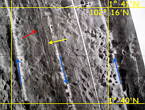
A DSL-120 sonar image of the same area. The field of small volcanic cones mentioned in the previous slide can be seen straddling the 102° 16’W longitude line. The yellow arrow points to the axial summit trough at the East Pacific Rise crest in this area. It is only about 100 meters wide. The red arrow points to an area where the walls of the trough have been hidden, probably by a recent volcanic eruption that flowed over them.
|
© 2010 Dive and Discover™. Dive and Discover™ is a registered trademark of
Woods
Hole Oceanographic Institution
