| Daily Updates: May
2003 |
| S | M | T | W | T | F | S |
| |
|
|
|
1 |
2 |
3 |
| 4 |
5 |
6 |
7 |
8 |
9 |
10 |
| 11 |
12 |
13 |
14 |
15 |
16 |
17 |
| 18 |
19 |
20 |
21 |
22 |
23 |
24 |
| 25 |
26 |
27 |
28 |
29 |
30 |
31 |
| Daily Updates: June
2003 |
| S |
M |
T |
W |
T |
F |
S |
| 1 |
2 |
3 |
4 |
5 |
6 |
7 |
| 8 |
9 |
10 |
11 |
12 |
13 |
14 |
| 15 |
16 |
17 |
18 |
19 |
20 |
21 |
| 22 |
23 |
24 |
25 |
26 |
27 |
28 |
| 29 |
30 |
|
|
|
|
|

TODAY'S WEATHER
Partly Cloudy
72°F (22.2°C)
Latitude: 38° 12'N
Longitude: 60° 31'W
Wind Direction: WSW
Wind Speed: 25 Knots
Sea State: 4-5
Sea Temperature: 70°F (21.1°C)
Swell(s) Height: 9 Foot
Barometric Pressure: 1007.5 MB
Visibility: 10 Nautical Miles

BREAKFAST
Blueberry pancakes with real maple syrup
Scrambled eggs
Sausage patties
Home fries
Oatmeal
Bagels
Fruit salad
Banana pecan muffins
LUNCH
Asparagus soup
London broil and zucchini ragout
BBQ chicken quarters
Baked beans
Egg salad sandwiches on rye
Corn chips
Ice cream bars
Assorted fruit
DINNER
Baked ham piri-piri (wild honey and lime juice)
Chicken Elizabeth (broccoli and white wine sauce)
Steamed rice
New potatoes
Fresh turnips and sugar snap peas
Cajun red beans with pork
Homemade assorted dinner rolls
Birthday cake and ice cream
A Dream Deferred
May 29, 2003
By Joe Appel
At 7:20 this morning, Chief Scientist Jess
Adkins was ecstatic. "Four years of planning," he said, "10 years
of dreaming, and here I am. It's just amazing."
The dream and the plan, of course, are to go with Alvin to the bottom
of the sea and find deep-sea corals. Everyone on board is passionate about what
the corals can tell us.
Adkins wasn't the only one in a state of great
anticipation. Many people had woken up early this morning (after
a rough and rolling night caused by 44-knot winds and 15-foot
waves), had skipped breakfast, in their desire to be there for Alvin's
first launch of the trip.
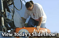
But it was not to be. A combination of mechanical trouble with the inflatable
Avon (see the slide show), and high gusts and waves, led the Expedition Leader
and the ship's Captain to cancel today's dive.
A subdued atmosphere spread through RV Atlantis after the announcement.
But another exploration tool stepped in to rally the troops. ABE, the autonomous
benthic explorer, was set to launch, big seas or no, by early afternoon.
ABE's purpose is to create high-resolution maps that cover relatively small areas.
Those maps will give us detailed information about the topography of the seafloor
that no other tool can.
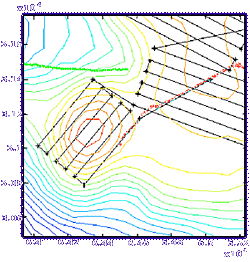
The track lines for today's journey by ABE
over Manning Seamount.
ABE is autonomous, which means that once it's
in the water, it goes without guidance from the ship. The vehicle's
inventor and master, Dana Yoerger, programs ABE with a dive plan.
At the heart of this plan is a series of track lines for ABE
to follow.
Other details are crucial as well: how deep
ABE should sink, the speed it should maintain, its altitude above
the seafloor, and which sensors it should have running.
But ABE also has rules it will follow in case
it encounters something that Yoerger couldn't have anticipated.
In other words, ABE has the ability to say, "Hey, you're up there
on the ship, you don't know what's really going on down here.
But I do."
ABE isn't due to arrive back on the ship until
6 a.m. tomorrow. No one doubts it will have valuable information
with it -- information that will prove even more valuable once
Alvin gets a look at Manning Seamount as well.
| Here
is the solution to the mapping problem in the May 28
journal |
Since
the box is 28 nautical miles (nm) wide, and each SeaBeam
can cover 4 nm, the ship must make 7 tracks. (28 divided
by 4 = 7).
The ship must cover each of those tracks for 45 nm. But remember that it can
turn 2 nm before it gets to the edge of the box and still cover the entire area
(since SeaBeam can cover 2 nm on each side). So, each track needs to be 41 nm
long, after subtracting 2 nm on each side of the 45 nm track.
Seven tracks multiplied by 41 nm = 287 nm.
In order to join all the tracks, the ship must make 6 small trips of 4 nm. (If
you draw the tracks on a printout of the map with the box, you'll see this).
Four nm multiplied by 6 trips = 24 nm.
287 nm + 24 nm = 311 nm that have to be covered.
A 311 nm trip when the ship is traveling at 11 knots (which is 11 nm per hour)
takes approximately 28.3 hours. (311 divided by 11 = 28.3).
Scientists Robinson and Gagnon plotted a track that did not cover the entire
boxed area, and they also had to cover some areas more than once (see the first
map to confirm this for yourself). This is because they had to keep making return
trips to the star point (see both maps) to deploy the navigation transponders
and then to be ready for Alvin's launch in the morning.
|
[Back to top]
|
