|
|
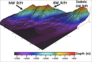
A 3-dimensional perspective image (looking to the northeast) of the western side of Fernandina Island. This image was made using data from our multibeam bathymetry survey. We discovered that Fernandina has three well-defined submarine volcanic rift zones: a NW Rift, a Central West Rift (not labeled), and a SW Rift. The SW Rift zone of Isabela Island was also covered by our survey. We conducted this detailed bathymetric survey to help better understand how oceanic hotspot islands like the Galapagos build up from the ocean floor. The bathymetry surveys we carried out will also be very useful to the Ecuadorian government to help them characterize the marine environment in the Galapagos National Park which covers all of the islands.
|
© 2010 Dive and Discover™. Dive and Discover™ is a registered trademark of
Woods
Hole Oceanographic Institution
