|
|
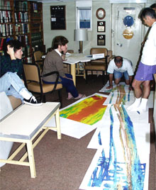
Chief Scientist Dan Fornari (far right) directs a meeting with his colleagues (from left, Maya Tolstoy, Rachel Haymon, Mike Perfit, kneeling, and Dan Scheirer) to discuss the plan for the first survey area on the East Pacific Rise between 9-10°N latitude. Multibeam bathymetry maps laid out on the floor provide key information on the mid-ocean ridge crest's topography and structure, which guides scientists to sites of potential volcanic eruptions.
|
© 2010 Dive and Discover™. Dive and Discover™ is a registered trademark of
Woods
Hole Oceanographic Institution
