|
|
TODAY'S WEATHER
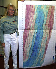
Uta Peckman displays one of the Galapagos Rift maps that covers 33 nautical miles. It is just about as tall as she is!
Lots of hot air! For most of this voyage, RV Melville has been operating in equatorial waters. Hot, sultry days are the norm, with light and variable winds, or no wind at all. During periods of calm, which can last for days or weeks, the surface of the sea becomes glassy -- almost like a mirror. The only apparent motion of the sea surface is caused by the long, low swells that have traveled thousands of miles to reach us having been generated by some distant storm. So, what's going on here? Why is there not more of a steady breeze? At other places Melville has worked, the wind blows constantly and strongly. Why do we have winds at all? The main cause of all winds is the unequal heating of the Earth’s surface. A good example of how wind is created by unequal heating can be found along many coastlines. The ocean is an enormous heat sink and moderator of temperature. Land is the opposite -- it heats up fast when the sun comes up, and cools off fast when the sun goes down. At night, as the land cools off, the air over it cools off too. The cooler air sinks, hits the ground, and spreads out laterally. This means that along the coast, the wind blows offshore, or away from the coast, in the morning. By about midday, the land is really heating up, while the water has a relatively constant temperature. As the hot air rises over the land, cooler air at ground level has to rush in to fill the void left by the rising air. Along the coast, the wind reverses and now blows onshore. Fishermen have known this for centuries, and used the morning offshore breeze to carry them to the fishing grounds, and the afternoon onshore breeze to take them home. On a global scale, unequal heating causes a general circulation pattern and predominant winds. If you imagine the rotating Earth moving around the sun, you can see that the equatorial regions receive the greatest amount of heat from the sun, while the polar regions receive the least amount of heat. The tilt of the Earth’s axis is what causes our seasons -- but that’s another story! Because of the uneven heating of the Earth, areas of high pressure and low pressure are generated. The air flows from high to low to try to even out the pressure. This creates wind. However, it doesn’t flow in a straight line from high pressure to low pressure. The rotation of the Earth affects the apparent path of the wind (this is known as the Coriolis effect), as does the elevation of the land. In the equatorial regions, hot air rises and a region of low pressure is created at the surface. Because the air is rising rather than moving laterally, there is little wind. Once it gets high in the atmosphere, the air cools and spreads out to the north and south. Somewhere in the mid-latitudes (30-40 degrees), the cool air begins to sink, forming a region of high pressure at the surface. Because the air is sinking rather than moving laterally, there is little wind here too. Air flows from these latitudes (high pressure) back to the equatorial region (low pressure) at the surface. The rotation of the Earth deflects the apparent flow of air from a north to south path. In the northern hemisphere, the flow is deflected to the right, creating the northeast trade winds. In the southern hemisphere, the flow is deflected to the left, creating the southeast trades. Over the ocean, the trade winds blow with a fairly constant force (15-20 knots) and direction. Over land, the trade winds are less constant because their flow can be interrupted by localized heating and changes in relief of the land. Over the centuries, sailors have given peculiar names to winds and regions. The equatorial area is known as the “doldrums” because of the lack of wind. In the days of sail, ships could get stuck here for weeks waiting for a breeze to come up. That could be quite depressing -- hence the name “doldrums”. It was not uncommon for a ship to launch her boats, with sailors pulling at the oars in an attempt to tow the ship out of the area! Another odd practice was a result of sailors’ superstitions. Whistling was generally banned on board ship for fear of whistling up a storm. However, in the doldrums, it was not unusual to see the Captain standing by the aft rail and whistling gently in the hopes of raising a breeze to move his ship along! Above the mid-latitudes, from about 40-55 degrees latitude, the prevailing winds are westerlies in both hemispheres. In the southern ocean, these latitudes were (and still are) another area of dread for sailors -- but for the opposite reason! Look at a globe and see how much land occurs between 40-55°S. There are hardly any land masses to interrupt the flow of the westerlies, and so they can attain significant speeds -- 30-45 knots on average. Constant winds of this magnitude cause enormous seas that make life aboard ship miserable. This band of latitude is called the “Roaring Forties”. The relief of the land can contribute locally to a wind’s character. For example, where mountain ranges are close to a coast, a cold wind can blow down the mountains and offshore with considerable force. This is called a “fall wind”. Fall winds can endanger small craft and making things uncomfortable for larger vessels. Off the west coast of Mexico and Central America, this kind of wind is called a “tehuantepecer”. The “pampero” off Argentina and the “mistral” wind of the western Mediterranean are also examples of fall winds. It seems as if all the nasty winds get the memorable names, but sailors have names for the gentle ones as well. A light breeze that just barely ripples the surface of the water is called a “cat's paw”. Nautical Trivia: the Beaufort Scale When we observe and report the wind, we note the direction it is coming from and the speed (expressed in knots aboard ship). When wind blows across the water, it first causes ripples to form. If the wind blows long and hard enough, these ripples build into waves. The effect of the wind on the water and the height of the waves produced, is called the sea state. Perhaps the best known scale of wind forces is that developed by Admiral Sir Francis Beaufort in 1806. Known as the Beaufort Scale, it is a series of numbers from 0 (calm) to 12 (hurricane) that indicates the strength of the wind. The scale was accepted by the British Admiralty in 1838, and the International Meteorological Committee adopted it in 1874. As originally written, the Beaufort Scale made no reference to wind speed. That was because Admiral Beaufort was a naval tactician, and his Scale was developed to assist ships’ officers in handling and maneuvering their vessels under certain conditions of wind. Hence, the Scale expressed the effect that certain amounts of wind would have on maneuvering a British Man-of-War, a ship with 40 guns. Over the years, various attempts were made to assign wind velocity ranges to the Beaufort Scale, often with conflicting results. Even though the age of sail died away, Beaufort’s numbers have survived as a common way of expressing wind strength. Today there is general agreement on the wind speeds for different Beaufort Numbers.
* - World Meteorological Organization
|
|||||||||||||||||||||||||||||||||||||||||||||||||||||||||||||||||||||||||||||||||||||||||||||||||||||||||||||||||||||||||||||||||||||||||||||||||||||||||||||||||||||||||||||||||||||||||||||||||||||||||||||||||||||||||||


© 2010 Dive and Discover™. Dive and Discover™ is a registered trademark of
Woods
Hole Oceanographic Institution
