|
|
TODAY'S WEATHER
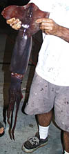
Last night, Dave Grimes and Dave Murline caught some enormous squid. They were bigger than the ones you usually see either in aquariums or on your dinner plate when you have calamari, the Italian name for squid. These squid will show up on our dinner plates in the next few days as delicious entrees. One benefit of being out at sea is getting fresh seafood almost any time. The “Daves“ are keeping us well stocked!
April 2, 2000 By Dr. Dan Fornari The sun rose hot and bright this morning over a sparkling blue sea. It was another beautiful day in the tropics, but you couldn’t tell if you were on duty inside the Control Van and paying close attention to operating and monitoring the DSL-120 sonar fish. The windowless van is usually kept dark so that people can see the TV and computer monitors better. After a four-hour watch, you walk outside and feel what a mole must feel like coming out of its hole-dazed and shocked at how bright the sun is. We are continuing to tow the DSL-120 sonar fish north and
south along the crest of the East Pacific Rise near 3° 20’N latitude.
We are flying the fish over a zone where the AHA hydrophones indicated that
earthquakes occurred four years ago. We are searching for evidence of that
seafloor volcanic eruptions took place here. We are also busy making maps
of the seafloor and we will post a few of them on the Web in the coming
days to give you a picture of what the seafloor looks like where we are
working. We don’t have maps right away because we are not taking photos
of the seafloor. We are bouncing sound waves off the seafloor and then “processing” this
data to make an image. In a way, we are translating sound into a picture.
Many techniques are used to process the many different types of data we
collect, and many people on board specialize in this work. Uta Peckman of
Scripps specializes in processing multibeam sonar data. Steve Gegg is the
expert data processor of the Woods Hole Deep Submergence Operations Group
on board. Tom Crook, also part of the Woods Hole team, is the expert navigation
data processor. Rob Palomares of Scripps is the expert processor of CTD
data (conductivity, temperature and depths of water). Dan Scheirer, Paul
Johnson, Gregg Kurras, Julia Getsiv and Scott White are all scientists working
on processing the different data we are collecting during this expedition.
|
||||||||||||||||||||||||||||||||||||||||||||||||||||||||||||||||||||||||||||||||||||||||||||||||||||||||||||||||||||||||||||||||||||||||||||||||||||||||||||||||||||


© 2010 Dive and Discover™. Dive and Discover™ is a registered trademark of
Woods
Hole Oceanographic Institution
