|
|
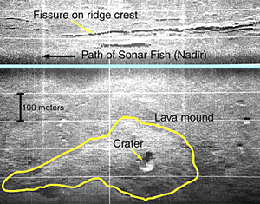
A DSL-120 sonar record collected today from the
East Pacific Rise crest near 9° 48’N latitude. The blue
line shows the path of the sonar “fish“. Bright areas
on the record are where a lot of echoes are returned to the sonar
fish from bumpy areas on the seafloor. Darker gray areas on the
record are places that are either smoother and so they reflect less
sound energy, or are in an “acoustic shadow” and so
did not receive the sound ping.
|
© 2010 Dive and Discover™. Dive and Discover™ is a registered trademark of
Woods
Hole Oceanographic Institution
