Introduction to the Galápagos Islands
by Dennis Geist
The Galápagos is a group of volcanic islands (sometimes called an archipelago); each of the 13 major islands is made up of at least one volcano. Isabela island, in the west, is the biggest island (over 75 miles long) and made up of six overlapping volcanoes: Cerro Azul, Sierra Negra, Ecuador, Alcedo, Darwin, and Wolf. The first three mean Blue Hill, Black Mountain, and Equator in Spanish. Alcedo is named after an Ecuadorian government official, and Darwin and Wolf after two of the most famous scientists to have visited the archipelago. Otherwise, the volcanoes and the islands share the same name, so when we say Floreana we mean both Floreana Island and Floreana Volcano.
The Galápagos Islands have three different geographic and geologic regions.
The western Galápagos are made up of Isabela and Fernandina. These arethe youngest islands in the archipelago and the region where we will be spendingmost of our time on this expedition. Although these islands make up the greatestsurface area in the Galápagos, only about a thousand people live in thewestern Galápagos, on the southeastern tip of Isabela. Fernandina is oneof the largest wilderness islands on Earth.
Most volcanic eruptions in the archipelago are from the western volcanoes, themost recent in 1998 at Cerro Azul, and in 1995 at Fernandina. The western Galápagosvolcanoes have a unique shape for a shield volcano, with especially steep flanks,and volcanologists have defined a category called Galápagos-typeshields. Because they are so young, with lavas that are all less than afew hundred thousand years old, geologists believe that these volcanoes markthe leading edge of the Galápagos hotspot.
The northern Galápagos is made up of Wolf, Darwin, Pinta, Marchena, andGenovesa islands (the names are confusing: Wolf and Darwin are volcanic islandsin the north but also the names of volcanoes on Isabela). The ages of these islandsare not well known, although in 1991 Marchena erupted. No one knows why theseislands formed here, but it probably has something to do with the hotspot leaking northwards,towards the Galapagos Spreading Center, part of the Mid-Ocean Ridge.
The central Galápagos comprises three main islands, San Cristobal, SantaCruz and Floreana and is where most of the population of the Galápagoslives. The Darwin Research Station is located on Santa Cruz island, which iswhere the main town of Puerto Ayora is located. Although there are some youngerlavas on these islands, on the whole they are much older -- ranging from about1 to 3 million years old -- than the islands to the west.
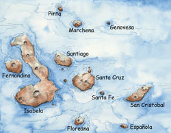
Watercolor painted map of the Galapagos Islands by E. Paul Oberlander, WHOI, with the major islands labeled.