|
|
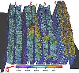
3-dimensional image of the Central Volcano area in the Galapagos Rift valley between Longitudes 97° 34’W (top of image) and 97° 38’W (bottom of image). The DSL-120 bathymetry data shown in this image was processed by Steve Gegg, Julia Getsiv and Greg Kurras. Each survey line is given a number (shown at the top of each swath of data). There is a gap in the data along the center of each swath. This is the seafloor directly underneath the DSL-20 sonar fish where no data are collected. This slide shows each line separately -- that is why there are gaps between them. Dan Scheirer took these data and created a computer program to fill in the data between the lines. The next photograph shows the excellent results of his data processing method. Depth bar at the bottom is in meters.
|
© 2010 Dive and Discover™. Dive and Discover™ is a registered trademark of
Woods
Hole Oceanographic Institution
