|
|
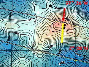
A small portion of the multibeam bathymetry map that Uta Peckman made using the data we collected of the Galapagos Rift valley near 97° 36’W Longitude. In this area, the DSL-120 sonar records showed a reflective ridge where we suspect there may be young lava. The red arrow points to the summit of the volcano associated with the ridge. They yellow bar shows the location of one of the dredge traverses we will do this evening.
|
© 2010 Dive and Discover™. Dive and Discover™ is a registered trademark of
Woods
Hole Oceanographic Institution
