Daily
Updates: March 2000 |
| S |
M |
T |
W |
T |
F |
S |
| |
|
|
1 |
2 |
3 |
4 |
| 5 |
6 |
7 |
8 |
9 |
10 |
11 |
| 12 |
13 |
14 |
15 |
16 |
17 |
18 |
| 19 |
20 |
21 |
22 |
23 |
24 |
25 |
| 26 |
27 |
28 |
29 |
30 |
31 |
|
| |
|
|
|
|
|
|
| Daily Updates: May 2000
| | S |
M | T | W | T | F | S |
| |
1 |
2 |
3 |
4 |
5 |
6 |
| 7 |
8 | 9 |
10 | 11 | 12 | 13 |
| 14 |
15 |
16 |
17 |
18 | 19 | 20 |
| 21 | 22 | 23 |
24 |
25 | 26 |
27 |
| 28 |
29 |
30 |
31 |
|
| |
Mission
Exploring for Mid-Ocean Ridge Eruptions
Join us for a 47-day cruise aboard the Research Vessel Melville during
Dive & Discover’s Expedition 3—as scientists
probe the dark depths of the eastern Pacific Ocean, looking for
new volcanic eruptions on the crest of the mid-ocean
ridge . .
The mid-ocean ridge is the Earth’s
greatest mountain range. It is made of many active underwater
volcanoes, where erupting lava cools when it hits cold seawater
and solidifies to create new seafloor.
Seafloor lava flows have strange and wonderful shapes. Some
look like they have been squeezed out of a tube of toothpaste
to form long cylinders with deep grooves in them. Others form
big, cracked pillows of rock that look like overstuffed sofas.
Some lava flows look like ropy swirls of black taffy.
How did these lava flows form? When did they
erupt? How do they build up to form the ocean crust of the
Earth? How are hydrothermal vents, like the ones studied during
Dive and Discover’s
first two cruises, related to these undersea eruptions and lava
flows? [See Expedition
1 or Expedition 2]
To answer these questions, scientists first
have to find where underwater volcanoes are actively erupting.
But in the vast, dark, deep ocean, how do you catch a submerged
volcano in the act? Scientists have come up with an exciting
new way that may work: they have set up an experimental array
of hydrophones to monitor thousands of kilometers of the mid-ocean
ridge and “listen” for
and locate sound waves generated by underwater volcanic eruptions.
Over the past three years, data collected
from the hydrophones have given us intriguing evidence that
seafloor eruptions have taken place at four locations along
the East Pacific Rise, the mid-ocean ridge in the Pacific Ocean.
This expedition will investigate whether eruptions have indeed
occurred at those four sites and prove whether the hydrophones
are reliable “ears” in
the ocean.
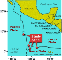
A team of geologists and geophysicists from
six institutions and government laboratories -- led by Dan
Fornari, Mike Perfit and Maya Tolstoy -- will survey the
target sites, between the Equator and about 10oN, aboard Scripps
Institution of Oceanography’s
RV Melville. Using the DSL-120 sonar and Argo II imaging
systems, they will make detailed sonar and photographic maps
of the seafloor. They will also
use dredges, rock corers and CTD (conductivity, temperature,
depth) instruments to sample lava flows and seawater, and sample
hydrothermal vents that may have been created when the eruptions
occurred.
Objectives
The primary objective of Expedition 3 is to study places on
the seafloor where volcanic eruptions have occurred very recently.
These underwater eruptions are one of the most fundamental
processes that shape the Earth and life on it. They are the
source of lava that creates new seafloor and of chemicals that
provide energy for exotic life in the deep. To really understand
how our planet works, we must understand where volcanic eruptions
take place, how long they last, and how they affect the seafloor, seawater,
and deep-sea organisms.
Scientists know that volcanic eruptions are happening all the
time at different places on the mid-ocean ridge axis. But to
study the new lava flows, we first have to find them. That is
very difficult to do, because the eruptions occur in the dark
depths of the vast ocean, where scientists have had no eyes or
ears. Until now that is!
Our colleagues at the National Oceanic and
Atmospheric Administration’s
(NOAA) Hatfield Marine Center, in Newport, Oregon have developed
an exciting new way to “listen” for sound waves generated
by volcanic eruptions over thousands of kilometers of the mid-ocean
ridge axis. It is called the Autonomous Hydrophone Array (or
AHA), and consists of six hydrophones spaced many hundreds of
kilometers apart. The hydrophones are placed in a special part
of the upper ocean between 600 m and 1200 m depth, called the
SOFAR (SOund Fixing And Ranging) channel. This channel acts almost
like a pipeline for sounds in the ocean. Sound waves travel straight
through the SOFAR channel without dispersing into ocean layers
above and below. The sound waves can travel thousands of miles
and still be detected. Since the mid-1940s when the SOFAR channel
was discovered, scientists, engineers and the military from different
countries have used this underwater pipeline to listen for submarines,
whales, and to study how sound travels in the ocean. Now ocean
scientists are using it to study volcanic processes on the mid-ocean
ridge crest.
Hydrophones record sound waves that are generated
by the cracking of the ocean crust as molten rock, or magma,
travels to the seafloor within the ocean crust, or as the lava
erupts on the seafloor. In 1996, six hydrophones were put out
in the eastern Pacific Ocean to listen for volcanic eruptions
between about 20°N latitude and 300°S latitude, a range of over
3000 miles (5400 kilometers). Every six months, NOAA scientists
and technicians have been going out on ships to pick up the hydrophones,
collect the data that they had recorded, put new batteries in
the recorders, and put the hydrophones back in place so they
can continue to monitor the ridge crest for eruptions.
Scientists in our research group have now
analyzed the hydrophone data collected over the past three
years and have located four sites on the East Pacific Rise
axis between the Equator and 10oN latitude where we think seafloor
lava eruptions have taken place. Will the AHA prove to be reliable “ears,” or
are they giving us misleading signals? Answering this question
is the primary goal of our expedition.
At each of the four target locations, we will use several different
survey methods and types of sampling equipment to determine if
recent volcanic eruptions have occurred and to see what effects
those eruptions may have had on the seafloor, seawater, and seafloor
life.
Surveys at each site will include:
- A detailed multibeam bathymetric survey
so that we can make a map of seafloor depths over large areas.
We bounce sound waves off the seafloor, which return to receivers
on the ship. The higher the seafloor, the faster the waves
return; the deeper the seafloor, the longer it takes for
the sound waves to return. In this way, we can make bathymetric
maps of the seafloor’s
topography. If the lava flows have built big structures (10 to
20 meters and bigger than a football field in area), such a map
might give us a clue as to where an eruption has occurred. These
data also provide a critical “road” map so that
we can safely navigate our next two types of mapping vehicles
along the jagged seascape.
- A survey using the DSL-120 side-looking
sonar system that probes the seafloor with high-frequency
sound waves and gives us “images” of
the seafloor terrain.
These tell us a lot about where lava has erupted on the ridge
crest and how lava flows across the seafloor. This vehicle
is towed 100 m above the seafloor and is connected to the
ship with a fiber optic cable so that scientists on board
the ship can collect data and “see” the seafloor as the vehicle
is towed over the seafloor.
- The Argo II imaging system provides the final
proof of actually seeing new lava. Argo II collects video and
digital pictures of the seafloor, and is towed only 10 m above
the seafloor. It also
is connected to the ship by the fiber optic cable, so scientists
see the images coming back from the ocean floor in real time.
- Once we find a new lava flow, we will take samples of the
volcanic rock using dredges and rock cores. The lava will be
analyzed on shore to tell us what its chemical composition
is; this will also help us determine how old it is. We will
also use a CTD (Conductivity, Temperature, Depth) rosette system
which will allow us to determine the salinity and temperature
of the water, and also to sample the water near the seafloor
for later analysis. If we observe any hydrothermal vents we
will try to sample the water near them and will use the dredges
to collect some of the sulfide minerals and the animals that
live near the vents.
|
